No, seriously. I think the effects of climate change on the jet stream will play havoc with agricultural production going forward.
Here's Dr. Jeff Masters with more on the
polar vortex:
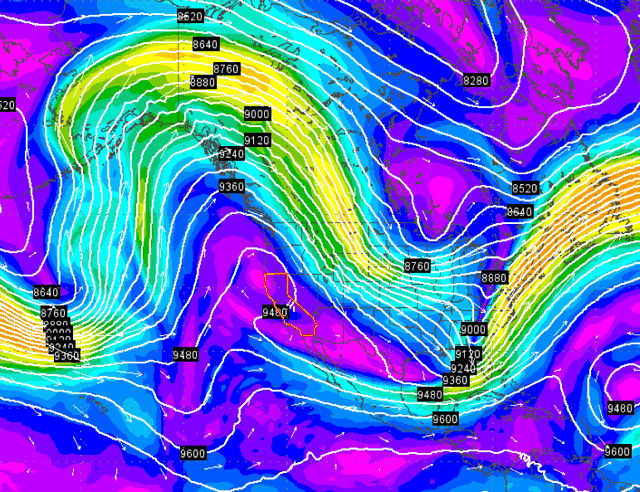
An extreme jet stream patten observed at 00 UTC on January 16, 2014.
Color-coded wind speeds at a pressure of 300 mb (roughly 9,000 meters or
30,000 feet) show the axis of the jet stream over North America, with a
large upside-down "U"-shaped ridge of high pressure over the West
Coast. California is outlined in orange. The strongest winds of the jet
stream (orange colors, 160 mph) were observed over the Northeast United
States, where a strong "U"-shaped trough of low pressure was anchored.
Image generated from the 00 UTC January 16, 2014 run of the GFS model,
and plotted using our wundermap.
From November 2013 - January 2014, a remarkably extreme jet stream pattern set up over North America, bringing the infamous "Polar Vortex"
of cold air to the Midwest and Eastern U.S., and a "Ridiculously
Resilient Ridge" of high pressure over California, which brought the worst winter drought conditions ever recorded to that state. A new study published this week in Geophysical Research Letters,
led by Utah State scientist S.-Y. Simon Wang, found that this jet
stream pattern was the most extreme on record, and likely could not have
grown so extreme without the influence of human-caused global warming.
The study concluded, “there is a traceable anthropogenic warming
footprint in the enormous intensity of the anomalous ridge during winter
2013-14, the associated drought and its intensity."
The researchers studied the historical pressure patterns for November -
January over North America during the period 1960 - 2014, and found that
a strong "dipole" pattern of high pressure over Western North America
and low pressure over Eastern North America, such as occurred during the
winter of 2013 - 2014, tended to occur naturally during the winter
immediately preceding an El Niño event. Since NOAA is giving a greater
than 50% of an El Niño event occurring later in 2014, this past winter's
dipole pattern may have been a natural expression of the evolving
progression towards El Niño. The study also found that the dipole
pattern could be intensified by two other natural resonances in the
climate system: the Arctic Oscillation,
and a variation of ocean temperatures and winds in the Western North
Pacific called the Western North Pacific (WNP) pattern. But the dipole
of high pressure over California combined with the "Polar Vortex" low
pressure trough over Eastern North America during November 2013 -
January 2014 was of unprecedented intensity, and extremes in this dipole
pattern--both in the positive and negative sense--have been increasing
since 2000 (the peak negative value occurred during the winter of 2009 -
2010.) The researchers used a climate model to look at whether
human-caused climate change might be interfering with the natural
pattern to cause this unusual behavior. They ran their climate model
both with and without the human-caused change to the base state of the
climate included, and found that they could not reproduce the increase
in amplitude of the dipole pattern unless human-caused global warming
was included.
I think farmers can expect more long dry spells and more long soggy wet spells going forward. Both drive me nuts, and both make grain production and markets more difficult, less stable and subject to greater extremes. Fasten your seat belts, folks, it's going to be a wild ride.
No comments:
Post a Comment